

Skip to content

framingham.com (*** TEST SITE ***)

News and local information about Framingham, MA (USA)

  • Home
    • Welcome
    • Site Map
    • Newsletter Sign-up
  • Local
    • Framingham Calendar
    • Framingham Weather
    • Framingham History
    • Framingham Organizations
    • Maps u0026 Transportation
    • Framingham Books
    • Framingham Cable TV
    • Downtown Framingham
    • Framingham Heart Study
    • More Local Links…
  • News
    • Around Town
    • Arts / Culture
    • General Interest
    • Business
    • Health u0026 Fitness
    • Home u0026 Garden
    • Politics
    • Public Meetings
    • Schools u0026 Education
    • Seniors
    • Technology
  • Business
    • Business Directory
    • Shopping Guides
    • Shop Route 9
    • Shop Saxonville
    • Shop Downtown
    • Shop Nobscot
    • Real Estate Guide
    • Dining Guide
    • Coupons and Savings
    • Coupon Book
  • Schools
    • Schools/Education
    • Homework Help
    • FHS-TV
  • Living
    • Health u0026 Wellness
    • Kids Pages
    • Seniors
    • Recreation
    • Religion
    • Collector’s Corner
    • New England Travel
    • Sports
    • Ski New England
  • GOV
    • Town Government
    • State Government
    • Federal Government
  • Help
    • Ask framingham.com
    • Privacy Policy
    • Contact Us
    • Advertising Info
  • Mass State Police Rt. 9 Framingham Heliport Airspace Designation Proposal

    Mass State Police Rt. 9 Framingham Heliport Airspace Designation Proposal

    FRAMINGHAM, MA – Massachusetts State Police Headquarters located on Route 9 near the Route 126 overpass seeks a higher level controlled airspace designation for it’s heliport.

    In an notice of proposed rulemaking, the Federal Aviation Administration (FAA), published notice of the proposal in the Federal Register titled “Proposed Establishment of Class E Airspace; Framingham, MA“, announcing a 45-day public comment period on the proposed rule.

    In a summary, the action proposes to “establish Class E airspace extending upward from 700 feet above the surface for MSP GHQ Heliport, Framingham, MA, to accommodate new area navigation (RNAV) global positioning system (GPS) standard instrument approach procedures (SIAPs) serving this heliport.”

    The reason stated is that “Controlled airspace is necessary for the safety and management of instrument flight rules (IFR) operations in the area.”

    The diagram below shows Federal Airspace Class Designations. Classes “B” and “C” look like upside-down layered wedding cakes — with larger amounts of airspace higher levels. The diagram uses the abbreviations: Mean Sea Level (MSL), Above Ground Level (AGL), Flight Level (FL).
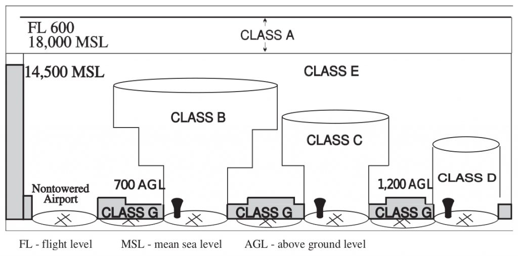
     

    [DIAGRAM] U.S. Aviation, Airspace Classes

    Send comments on this proposal to: the U.S. Department of Transportation, Docket Operations, 1200 New Jersey Avenue SE, West Building Ground Floor, Room W12-140, Washington, DC 20590-0001; Telephone: (800) 647-5527, or (202) 366-9826. You must identify the Docket No. FAA-2020-1195; Airspace Docket No. 20-ANE-11, at the beginning of your comments.

    You may also submit comments through the internet at: https://www.regulations.gov.

    Comments must be received on or before March 5, 2021.

    The Federal Register announcement of this proposal was published on January 19, 2021 and can be viewed here.

    ###

    News Staff

    January 19, 2021
    Legal Notices, Uncategorized
    aviation, faa airspace, framingham airport, helicopter pad, heliport, MA State Police, State Police Barracks

Proudly Powered by WordPress