Skip to content

framingham.com (*** TEST SITE ***)

News and local information about Framingham, MA (USA)

  • Home
    • Welcome
    • Site Map
    • Newsletter Sign-up
  • Local
    • Framingham Calendar
    • Framingham Weather
    • Framingham History
    • Framingham Organizations
    • Maps u0026 Transportation
    • Framingham Books
    • Framingham Cable TV
    • Downtown Framingham
    • Framingham Heart Study
    • More Local Links…
  • News
    • Around Town
    • Arts / Culture
    • General Interest
    • Business
    • Health u0026 Fitness
    • Home u0026 Garden
    • Politics
    • Public Meetings
    • Schools u0026 Education
    • Seniors
    • Technology
  • Business
    • Business Directory
    • Shopping Guides
    • Shop Route 9
    • Shop Saxonville
    • Shop Downtown
    • Shop Nobscot
    • Real Estate Guide
    • Dining Guide
    • Coupons and Savings
    • Coupon Book
  • Schools
    • Schools/Education
    • Homework Help
    • FHS-TV
  • Living
    • Health u0026 Wellness
    • Kids Pages
    • Seniors
    • Recreation
    • Religion
    • Collector’s Corner
    • New England Travel
    • Sports
    • Ski New England
  • GOV
    • Town Government
    • State Government
    • Federal Government
  • Help
    • Ask framingham.com
    • Privacy Policy
    • Contact Us
    • Advertising Info
  • Downtown Framingham Traffic About to Get a Little Worse

    Downtown Framingham Traffic About to Get a Little Worse
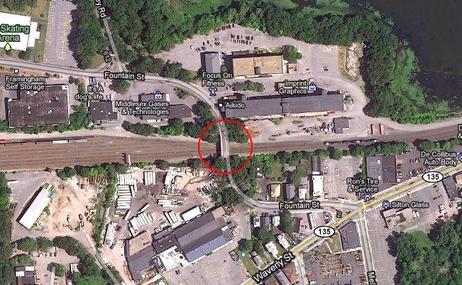
    Map of Fountain St. bridge replacement work area in Framingham, MA
    The Fountain St. bridge is frequently used to avoid Downtown Framingham and navigate to and from the Merloni Baseball Complex, Loring Arena, Keefe Tech, Fountain Street Galleries, (and other businesses located in the former Bancroft Cap factory), and the surrounding area. Map courtesy of Google Map, http://maps.google.com/

    FRAMINGHAM, MA – Long recognized as one of the worst things about Downtown Framingham, traffic along the Rt. 126 corridor through the Rt. 135 intersection and rail crossing is about to get even worse — temporarily.

    Construction is slated to begin June 23, 2011 to replace the Fountain St. bridge which some motorists use as an alternate route to avoid the traffic choked Downtown central district.

    MassDOT and its contractor estimate the project will take 97 days and, baring any unforeseen circumstances, the projected bridge re-opening date is set for September 27th, (2011).

    The $2.3 million dollar state and federally funded project includes (more…)

    News Staff

    May 16, 2011
    General Interest
    bridge replacement, bridge work, concord st., csx, detours, Downtown Framingham, Farm Pond, Fountain Street, framingham traffic, loring arena, MassDOT work in Framingham, MBTA, planing, rt 126, rt. 135, school busses, summer of 2011, traffic, waverley st., waverly st., Winter Street
  • Route 126 Corridor Transportation Improvement Study Approved

    FRAMINGHAM, MA – On May 20, 2009 the Metrowest Legislators announced that the Boston Metropolitan Planning Organization (MPO) has approved a Route 126 Corridor Transportation Improvement Study that will encompass the towns of Bellingham, Medway, Holliston, Ashland and Framingham. Work is set to begin immediately.

    The objectives of the study are to identify mobility, access, safety, and other transportation-related problems at selected locations along Route 126 and to identify and evaluate multimodal transportation solutions to the problems, with the goal of improving accessibility to the towns’ shopping, commercial, educational, and service centers.

    “Route 126 is extremely important to the towns included in this study, as well as the greater MetroWest region, connecting as it does to 1-495, Route 16, Route 109, Route 135, and Route 140,” stated Senator Karen Spilka. “This study is great news for these towns and the region as a whole, as we continue our efforts to grow smart and grow strong.”

    The first step in the project will be the formation of an advisory task force that includes town officials, affected residents, members of the Metropolitan Area Planning Council (MAPC), the Massachusetts Highway Department, and the Executive Office of Transportation and Public Works, as well as local Senators and Representatives. This task force, which is scheduled to meet once in mid-June and once again within twelve months, will participate in the study by offering advice and input on data, study location selections, and recommendations.

    “The Route 126 corridor is a main thoroughfare in the Town of Framingham,” stated Representative Pam Richardson. “It is a crucial component in the economic development and revitalization of our downtown. I am looking forward to working on the task force, the outcome of the study and the subsequent improvements to this important corridor.”

    The end result of the study will be recommendations for geometric, traffic control, and other changes for improved traffic operations, with special emphasis on the effective and safe accomodation of pedestrians and bicyclists. Bus service improvement recommendations may also be developed. A long-term vision for the Route 126 corridor compatible with the land use and economic development in the area is also expected.

    “The development of Route 126 is a quality of life issue for the people of my district” stated Representative Tom Sannicandro. “The jobs and economic development that will come from these proposed transportation improvements will not only transform much of Ashland and Framingham, but all of Metro West.”

    All results will be presented for discussion and input at the second meeting of the advisory task force. A final report documenting all of the project’s tasks and products, including its recommendations, will be submitted to the Transportation Planning and Programming Committee of the MPO for final approval.

    ###
    Deb Cleveland

    May 27, 2009
    Politics
    concord st., Karen Spilka, pam richardson, Route 126, rt 126, Tom Sannicandro
Previous Page
1 2

Proudly Powered by WordPress