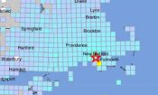
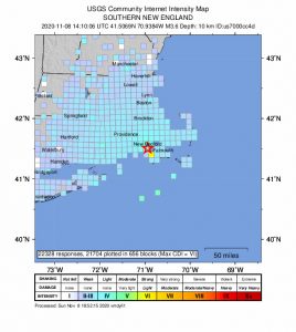
USGS National Earthquake Information Center (NEIC) “Felt It” Map, of Buzzards Bay MA earthquake, November 8, 2020 at 9:10am.
FRAMINGHAM, MA — Did you feel mild ground shaking this morning? Thousands of residents of Massachusetts, in areas from Cape Cod to Metrowest to the Berkshires and into Connecticut reported feeling light tremors to The U.S. Geological Survey (USGS).
The USGS reported a 4.0 magnitude earthquake occured (more…)
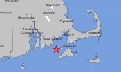
FRAMINGHAM, MA – Two small earthquakes were detected less than 15 miles off Cape Cod last night.
At 8:39PM, a Magnitude 2.1 quake was detected, followed by a lessor, Magnitude 1.3 tremor at approximately 8:46PM .
Two small tremors detected off coast of Cape Cod. Map image based on official U.S. Geological Survey, (USGS), data pinpoint the location of the quakes which were detected less than 70 miles from Framingham, MA.
The quakes, which were centered 12 miles from Woods Hole Oceanographic Institute, approximately 14 miles west of Martha’s Vineyard — 15 miles from New Bedford with the epicenter only 67 miles southwest of Framingham.
Seismologists for the New England Seismic Network of the Weston Observatory of Boston College confirmed the data, (officially USGS Earthquake Event ID #ne00001256 and #ne00001257).
By comparison, the quakes which devestated Japan earlier this year were in the 9+ Magnitude range, effecticely thousands of times stronger than these small tremors which were too weak to be felt on land.